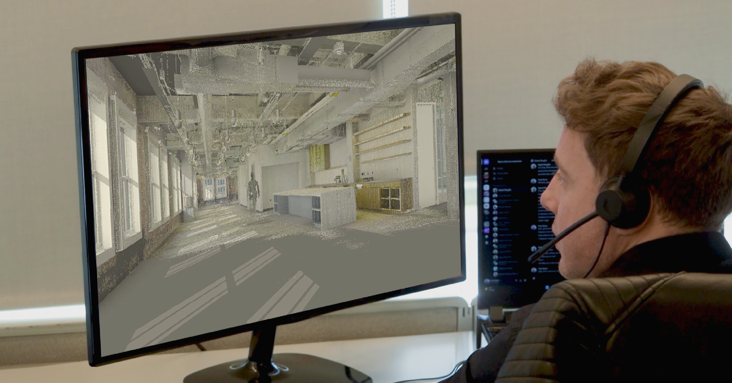
3D laser scanners and reality-mapping tools are ushering in a new era of construction documentation. High-resolution LiDAR devices and 360 cameras can quickly convert a chaotic jobsite into a precise digital model, capturing every beam, pipe, and wall before it’s hidden. This reality mapping process means that engineers and architects work from an updated digital twin of the building under construction. Instead of combing through field notes or travel schedules, stakeholders can explore the model remotely, even rewinding time to see how the site looked at earlier phases.
Such live models deliver unprecedented visibility into site conditions and eliminate costly guesswork. For example, on a 600,000 square foot renovation, the firm TowerPinkster used laser scans to document hidden MEP systems. Architects then reviewed the point clouds to validate design decisions that would have otherwise taken weeks of manual measuring. In short, scanning makes the entire site accessible as digital data, enabling teams to measure, annotate, and share information more quickly than ever.
Digital twins and 4D BIM integration
The 3D scan data becomes even more powerful when linked with schedule and design information. By feeding point clouds into BIM software, teams create a digital twin for construction – a frequently updated virtual replica of the asset that incorporates the master schedule and design models. In practice, this means every captured scan is tagged to a date or milestone, yielding a 4D BIM timeline of the build. Project managers can overlay the as-built point cloud on design drawings to spot deviations instantly or see where each trade’s work stands in the critical path. This single source of truth improves stakeholder communication, optimizes decision-making, and improves risk mitigation.
Rather than relying on fragmented reports, all teams work from the same up-to-date model. Modern reality-mapping platforms even allow workers to pin issues (clashes, omissions, safety hazards) directly on the 3D model and assign resolutions, streamlining coordination. Over the project lifecycle, the goal is an as-built digital twin: a dynamic 3D record of what was actually built. By the end of construction, this model can be exported as final as-built documentation, accelerating handover to owners and facilities teams.
Real-time progress monitoring with 360 capture
Frequent site scans keep the digital twin synchronized with reality. Affordable 360-degree reality capture technology, such as helmet-mounted or tripod cameras, lets virtually anyone on site document progress in minutes. A quick 360 photo at each trade handover or weekly milestone produces an immersive panorama tied to the schedule. Software automatically stitches these images into the 4D model so remote teams can log on and “walk” the job virtually. Construction progress monitoring becomes continuous and measurable: superintendents compare each capture against the planned BIM and master schedule to compute percent-complete for every activity.
This digital snapshot approach replaces laborious site walks and checklist reports. As one industry guide notes, managers can keep tabs on projects from afar, and comprehensive progress monitoring helps facilitate a successful end-of-project handoff. In practice, this means delays or errors are spotted days or weeks earlier. For instance, if steel framing lags, the model shows missing geometry that triggers an RFI long before misaligned columns would cause rework. By automating progress capture, teams dramatically cut down on delays and last-minute fixes – studies show good scan documentation alone can eliminate weeks of manual surveying and paperwork.
By linking scans to schedules, the model also powers richer analytics. In fact, contractors now merge reality data with 4D simulations so that every photo or point cloud update effectively becomes part of a live schedule. There’s even a “time machine” effect: project teams can rewind the digital twin to inspect earlier stages in detail, aiding claims review or design validation. Throughout construction, all checks and inspections (for example, code compliance walkthroughs or trade punch lists) can be done virtually on the model instead of making repeated site visits. This construction site monitoring and inspections workflow ensures nothing is overlooked. Every element has been captured in the scan, and the digital twin becomes the definitive record of progress and quality.
Quality control, coordination, and risk management
Beyond visualization, 3D scanning considerably sharpens precision and collaboration. Modern laser scanners deliver millimeter-level accuracy across entire buildings, meaning teams get exact measurements for every structure and subsystem. This precision speeds fabrication and fit-up: if a beam or duct is misaligned even slightly, the scan will reveal it before installation. The result is far less rework. Indeed, using the digital twin for Visual Quality Assurance and Quality Control means spotting and fixing deviations instantly. With a click, stakeholders see the point cloud overlaid on the design – if anything is off, they mark it and assign corrective tasks all within the model. Owners and contractors cite this visual QA process as a major time saver, since it avoids the old cycle of on-site inspection, re-drawings, and costly do-overs.
Safety and risk also improve with smart scanning. Hazardous inspections – like checking under a high-rise deck or inside confined machinery – can often be done remotely using the digital twin. Inspectors put on VR or simply pan around the 3D model to examine potential issues without entering danger zones. Meanwhile, constant reality capture creates a record that helps manage claims: teams can refer back to exactly what was built on a given day, reducing liability. Even after the ribbon-cutting, the scan data finds new uses.
Many owners treat the finished model as an as-built digital twin for facilities management. For example, detailed 3D BIMs of bridges, tunnels, and roadways (created from field scans) allow infrastructure agencies to perform infrastructure inspection virtually. One industry report notes that 3D LiDAR scanning is transforming infrastructure inspections by offering a non-intrusive solution that is also precise, mapping every crack and flaw in high resolution. Planners then use these scan-derived twins to analyze wear, simulate stress, and plan maintenance long before problems appear. In sum, integrating 3D scanning into workflows enhances coordination, accuracy, and safety at every phase, from ground-breaking through ongoing asset management.
3D laser scanning and reality capture are no longer optional—they’re becoming essential to ensure accuracy, reduce risk, and accelerate project delivery. By integrating digital twins and 4D BIM workflows, construction teams gain unmatched visibility and control over every stage of the build. At Voyansi, we help owners, architects, and contractors harness these technologies to streamline coordination, cut rework, and deliver better outcomes.
Ready to see how reality capture can transform your next project? Book a free 30-minute consultation with our experts today and start building smarter.